|
Al Hijr, MADA’IN SALEH is located 22 kilometers from Al Ula. It occupies a strategic position on the road linking southern Arabian Peninsula, Mesopotamia (modern day Iraq), Syria and Egypt.
In Al Hijr the road coming from south of Arabia divides out into two branches: one heading to the north ending in\\\', Petra in Jordan, which was the political capital of Nabataea’s, passing through Tabuk, and the second branch heading towards Mesopotamia through Tem\\\'a. This important strategic location has made Madain Saleh to become the capital of Nabataea and an important economic and trade destination of caravans.
General Information
Al Hijr or Madain Saleh is an archeological site in Saudi Arabia, located in the Al Ola governorate of Al Madinah province and occupies a strategic position linking south of Arabia with Mesopotamia, Syria and Egypt. It was the land of Thamoods in the Wadi Al Qurah, \\\"Valley of Villages\\\", lying between Al Madinah and Tabouk. Al Hijr is also known as Madain Saleh, the Saleh’s village.
Al Hijr is located to the north east of Al Ula, 47-26 North Latitudes and 53-37 East Longitudes. It is known as Al Hijr since the ancient times. The people who resided in this place were called Koran. According to Quran, the Thamoods had met the missionaries of the prophet Saleh and then they converted to his religion, after slaughtering a she-camel sent to them by God.
Views
According to archeologists, Al Hijr was inhabitant by Al Moaineen and Al Thamoudains in the third millennium BC. Before them the place was occupied by the Lehainians in the 9th century BC. Nabateans invaded the state of Bani Lehain, who used stone structure as their houses, temples and tombs. It is believed that Nabateans had built the city of Al Hijr themselves as it revealed through the inscriptions found. Al Hijr contains a great deal of Moaineen and Lehain inscriptions that link Al Ula, Kheriba and Hiania towns as oldest perhaps dating back to 1700 BC. Some of these places were destroyed by earthquakes, according to the established literature.
As for Al Hijr city, its antiquities belong to the Mea\\\'nains traders and the early Thamoudains who had migrated into it from the south of Arabian Peninsula.
In 2008 United Nations Educational, Scientific and Cultural Organization (UNESCO) had announced that the archeological site of Madain Saleh was included in the world Heritage List. Thus becoming the first site in Saudi Arabia to join the World Heritage List.
Nabateans,
It has been proved to the researchers that the Nabataeans were the first to settle in Al Hijr, \\\"Madain Saleh,\\\" and hence are the original architects of Al Hijr. researchers believe that the Nabataeans had originated from the Arabian Peninsula. Historian Dedor Al Saqali writes that, the Nabateans were a nomadic herdsmen tribe, who did not know the art of Agriculture. These people had no sedentary life nor did they drink alcohol and that their land was mostly rocky and rugged, unfit for a sedentary life.
It is understood that the Nabateans had founded a large kingdom and its capital was Petra ‘Sila\\\' located to the north of Mada’in Saleh. The sources of the oldest evidence to the existence of Nabateans date back to the ninth century BC, which was the beginning of their kingdom in the city now known as the Sila\\\', Petra. When they decided to control the ancient trade route, they founded their capital at Al Hijr city.
Through Nabateans inscriptions found in the Madain Saleh we can determine the age of Kingdom of the Nabataea’s, as it starting from the beginning of the first century BC to the mid-second century AD.
Nabateans had faced many economic and political challenges, particularly with the Roman Empire. It was the biggest problem and a major challenge faced by the Nabataea, as it was decidedly isolated and finally leading to its downfall and decay. It was the discovery of the seasonal trade winds in the first century BC which resulted in the adoption by neighboring countries and the owners of commercial convoys to transport their goods through Red Sea, resulting in the vulnerability of Al Hijr, which was dependent on the passage of the convoys through its land and levying tax on it for its own prosperity.
When convoys pass through this
ancient city with vibrant landscape and golden hills on the far-left it was one of the best scene in the Arabian Peninsula.
From the available inscriptions the Nabateans language resembles the late Aramian language which was greatly influenced by Arabic language. 700 years before the birth of Prophet Muhammad (Blessings and peace be upon him), the Kingdom of Nabateans extended from Damascus to the Red Sea. But in 63 AD it was annexed by Rome and in 106 AD the Emperor Trojan transformed it to Romanian province with the rest of the Arabian Peninsula.
The success of Nabateans was due largely to the presence of the best architects of the ancient world with them. They were able to overcome the scarcity of water sources in the region through a network of pits and canals to harness and store water, some of which are in use.
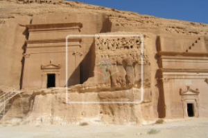
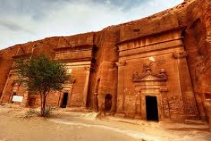
The remains of Madain Saleh, testify to the remarkable work of engineering. More than 131 tombs were found which were carved out of huge sandstone mounds, standing singly amidst the world of wavy sands, as well as some in a state of decomposition. The names engraved on these belong to the local Bedouins tribes.
Going clockwise, the first tomb to be seen is Al Sane tomb as an introduction to the key elements of the model of the Nabatean tombs. It has a great interface, with the figures of five components, and the inscriptions at the top of the door and the niches into which the dead bodies were placed.
Al Kheremat is next location with twenty shrines in good condition. It is one of the best preserved tombs in the Madain Saleh. There are many symbols that appear to be linked to generations of the cultural imagery borrowed from the Egyptians and Ethiopians. Statuettes of winged lions with human body and forms of flowers painted on the bowls used in the rituals associated with funerals testify to this. Al Khremat houses were built of mud as well as they contained water well.
The Jabal Ithlib
This toponym refers to two mountain ranges which dominate the site from the northeast. These mountains, with their high peaks, were particularly important for the Nabataeuans since they chose them to be their religious area. They thus carved inside the Jabal and on its outline, various type of sanctuaries and other structures related to the cults of rituals they practiced there. One of them called the Diwan is a room for banquets near which are carved several niches with betyls.
According to the explorer Charles Doughty (1888 AD), there was a threshold in the palace that has fallen down with the extension of the ceiling. “Also this room is pleasant and cool, because the north facing façades allow no direct sun rays into them, and the cool air is always fills the space\\\" he said. There is a deep sense of security and calm in the tomb which makes it gravely solemn.
Climbing over the mountain of Ethleb, on will face enthralling scene over Madain Saleh. Out at the palace of Al Bint are painted whales in triangular forms as the guards of the tomb. This is an example of the influence of Greek art on the Nabateans. The construction of the tomb has been halted midway, which gives helps to offer an insight into the techniques of tomb construction by the Nabateans. The construction starts from the top going to the bottom. Flowers on its entrance and the other ones depict decorated plates used in religious ceremonies, indicating that these buildings contained graves.
The unique place is the Bani Lahain Bani Quza, which is a distinct tomb, carved out of an isolated rock facing the west. It is also incomplete. It has a special beauty when the sun blazes on it in the afternoon.
Eating and sleeping is prohibited inside Madain Saleh. 6 kilometers from Madain Saleh is the old and abandoned Hijaz Railway lines and the station building.
|


.jpg)